
Lithological characterization of the Menga stones
The 32 analysed stones (24 orthostats, 5 capstones and 3 pillars) belong to 5 different lithological types (Figs. 1, 2, Table 1). We have identified a first group of bioclastic sandstones in a broad sense and another one of breccias. Bioclastic sandstones commonly show a significant amount of subrounded quartz grains (sometimes in the form of a micro-breccia with clasts perforated by lithophagous organisms) poorly cemented by a shallow matrix of calcium carbonate (Fig. 1b–d). The breccias present a calcareous matrix and/or cement with sharp clasts of oolitic limestone, slate, ophites, marly limestone and iron oxides, with sizes ranging from medium sand to gravel.
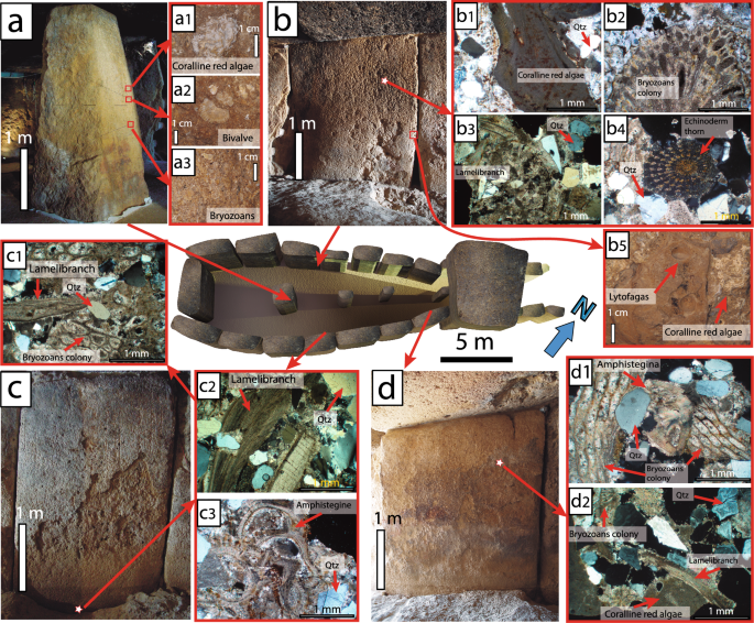
3D Model of Menga drawn with AutoCAD showing the biofacies (microfacies) present in the stones. The fourth pillar, currently missing, has been added, while capstones C-2, C-3, C-4 and C-5 have been removed in order to show the interior of the monument (Lozano Rodríguez et al.25). (a) Pillar P-3 with examples of biofacies (a1–a3 observed in hand specimen). (b) Orthostat O-15 with examples of biofacies (b1–b4 observed petrographically) and in hand specimen (b5). (c) Orthostat O-8 with examples observed petrographically (crossed polars) (c1,c2). (d) Orthostat O-5 with examples observed through the petrographic microscope (d1,d2). The star-shaped symbol indicates the place where a section was made for the petrographic study. Qtz: Quartz (designations after Kretz,49).
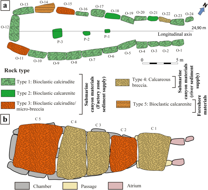
Schematic design of Menga showing the distribution of facies in the stones. (a) Without the capstones. (b) With the capstones (P: Pillar; C: Capstone; O: Orthostat) (Modified from Lozano Rodríguez, et al.25).
Lithological Type 1 includes bioclastic calcirudite with rudstone textures and can be found in 18 out of the 24 orthostats. Type 2, which includes bioclastic calcarenite but with packstone-rudstone textures, is used for two orthostats (both on the right-hand side of the megalithic chamber at the monument’s entrance), and in all three pillars. Type 3 corresponds to orthostats O-11 and O-15 and capstones C2 y C5, which were made with bioclastic calcirudite/micro-breccia with rudstone texture (Fig. 2). These three typologies are characterized by a mineralogical composition mainly of calcite and to a lesser extent quartz (Fig. 1b1,b3–4,c1–3,d1–2), limestone, iron oxides, feldspar and glauconite. The skeletal grains of these materials comprise fragments of bryozoans (Fig. 1a3,b2,c1,d1–2), bivalves (Fig. 1a2,b3,c1–2,d2), echinoderms (Fig. 1b4), coralline algae (Fig. 1a1,b1,d2), benthic foraminifers (Fig. 1c3,d1), and minor brachiopods and balanids with parallel lamination and syndepositional intergranular voids (Table 1). Type 4 corresponds to calcareous breccia with rudstone texture. This type appears in one of the stone orthostats (O-22) of the right-hand side of the chamber (at the entrance) and in capstones C1, C3 and C4. It is characterized by a mineralogical composition mainly of calcite, quartz, feldspar, iron oxides and flint, partly covered by sands. Skeletal grains are composed by fragments of bivalves, bryozoans, and coralline algae with syndepositional cement. Textures show low-angles, parallel laminated and overlapping edges (Table 1). Finally, Type 5 is found only in one of the stone orthostats (O-14) and is composed by bioclastic calcarenite with rudstone texture. Its mineralogical composition mainly consists of calcite and to a lesser extent quartz, iron oxides, feldspar and glauconite. This texture also shows skeletal grains composed of fragments of bivalves, brachiopods, spines from echinoderms, bryozoans, and echinoderms with syndepositional intergranular voids, low-angles, parallel laminated and burrows (Table 1).
In general, these stones range from soft to moderately soft according to the International Society for Rock Mechanics (ISRM) (Table 1). Our measurements show they are highly porous rocks with porosities ranging from 13.67% for type 1 (calcirudite), 13.29% for type 2 and 5 (calcarenite), 22.91% for type 3 (calcirudite/micro-breccia) and 29.62% for type 4 (breccia). We estimated apparent densities of 2321 kg/m3 for type 1; 2366 kg/m3 for type 2 and 5; 2237 kg/m3 for type 3 and 2318 kg/m3 for type 4 corresponding to real density of the stone materials of 2688 kg/m3; 2729 kg/m3; 2902 kg/m3 and 3294 kg/m3 respectively. Previous studies on the same rocks found similar apparent densities of 2264 for type 1; 2039 for type 2 and 2488 kg/m3 for type 430 composed of poorly cemented, mostly bioclastic sandstones (see Fig. 1b–d). Simple compressive strength was 12, 80–34, 98 MPa for type 2, 15, 52–36, 15 MPa for type 1 and 22, 46–57, 30 MPa for type 430. Type 2 from the same period in the nearby area of Granada, showed simple compressive strength of 13Mpa30 and apparent densities of 1741 kg/m3 ± 631 and 1960± 0.39 kg/m332, consistent with stones that can be easily carved.
Characterization of the Upper Tortonian materials surrounding the Menga Dolmen
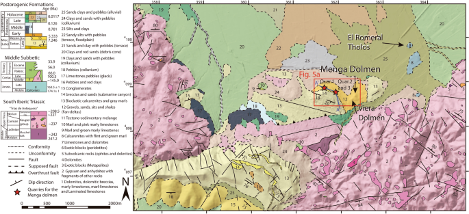
In the surrounding area of Menga, materials of Upper Tortonian age include rocks generated in a temperate carbonate palaeoenvironment. These carbonates occurred in a narrow platform observable in small outcrops through the northern margin of El Torcal, a massive karst formation located 11 km south of Antequera. These rocks are interspersed with other detrital sedimentary materials of the same age that rest on a substrate of Triassic (~252–~201 Ma) and Jurassic (~201–~145 Ma) materials (Fig. 3).
In the Antequera calcarenites, the factory paleoenvironment is virtually eroded -with the exception of a small outcrop at the southwest of Antequera city (Fig. S4), yet a sequence of a filled submarine canyon can be identified. This submarine canyon resulted from rivers that penetrated towards the marine platform, and whose head became totally individualized, without continental inputs. The submarine canyon was later filled with sandy and silty sediments carried by longshore currents. Over time, the infill of the submarine canyon was formed in several phases. The first phase was a marine regression with erosion. The second phase involved partial abandonment of the sedimentary load transported by the submarine river, generating conglomerate deposits at the beginning of the marine transgression. The last phase involved the upfilling of the submarine canyon with sediments, in the final stage of the transgression. A similar process has been described for the palaeo-bay of Alhama de Granada33.
At the base of the stratigraphic column there are uncemented sands, polygenic and heterometric (fine and coarse) gravels, larger boulders wrapped in a matrix rich in fine sediments and small layers of silts and shales. These uncemented materials, which contain abundant soft and angular clasts, extend over the area on which both dolmens were built (Fig. 3) and represent a high-energy environment. These are the facies that allow us to interpret the typical paleoenvironment of fan-delta materials.
Fan-deltas face towards the interior of today’s Antequera Depression. Overlaying those materials, with a thickness of about 4 m and in a discordant manner, lay bioclastic calcirudites very well classified with parallel lamination, corresponding to a foreshore (beach) paleoenvironments. These materials can only be seen in the stratigraphic column at Los Remedios neighbourhood, inside modern-day Antequera, about 700 m south-west from Menga (Fig. 4a). On these materials, and also in a discordant manner, there is a polygenetic and heterometric calcareous breccia, with high-energy oriented pebbles and some presence of perforations by lithophagous organisms and iron oxides. The clasts of this fabric are locally encumbered by poorly cemented, well classified and subrounded sands (Fig. 4c,d). Similar materials can also be seen in the stratigraphic column at Cerro de la Cruz (Fig. 4a,e,f) in stratigraphic correlation under the shoals’ palaeoenvironment and above the fan-delta one. However, in this location, the breccia is the best cemented and the amount of iron oxides is the lowest, corresponding to a submarine canyon palaeoenvironment (river sediment supply). Halfway between the stratigraphic columns of Los Remedios neighbourhood and Cerro de la Cruz, but closer to the latter, there is a small outcrop (currently only about 10 m2 are preserved) that includes bioclastic calcarenites and calcirudites, with large amounts of bryozoans, coralline red algae, bivalves and pebbles (Fig. 4b). This outcrop changes laterally towards a micro-breccia, extending a few meters farther (Fig. 5a). This lithology corresponds to submarine canyon paleoenvironments, in this case with a factory zone sediment supply, embedded in a discordant manner above the shoals in the NW (Figs. 4a,b, 5a and S4a–c). The shoals’ materials are the thickest ones, reaching up to 8 m at some points. They are bioclastic calcarenites and calcirudites with through cross-bedding (Figs. 4a–c,e, 5a and S4b).
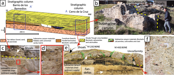
(a) Stratigraphic correlation of the Upper Tortonian sedimentary materials in the Los Remedios neighbourhood and Cerro de la Cruz. (b) View of the small outcrop of type 1 and 2 stones (submarine canyon), embedded by erosion in the shoals materials, preserved at Cerro de la Cruz. (c) Stratigraphic section at Los Remedios neighbourhood, showing the submarine canyon materials below the shoals. (d) Detail of the matrix-supported marine materials with large amounts of pisoliths and minor bryozoans and red algae or lamellibranchs. (e) Overview of the submarine canyon materials at Cerro de la Cruz, above the fan-deltas. Note the subvertical tectonic fracturing, which is perpendicular to the valley, displaying little tectonic penetration at metric scale, which favoured the extraction of large blocks. (f) Detail of well-cemented sedimentary materials at Los Remedios neighbourhood, with smaller amounts of pisoliths and local bryozoans and red algae or lamellibranchs.
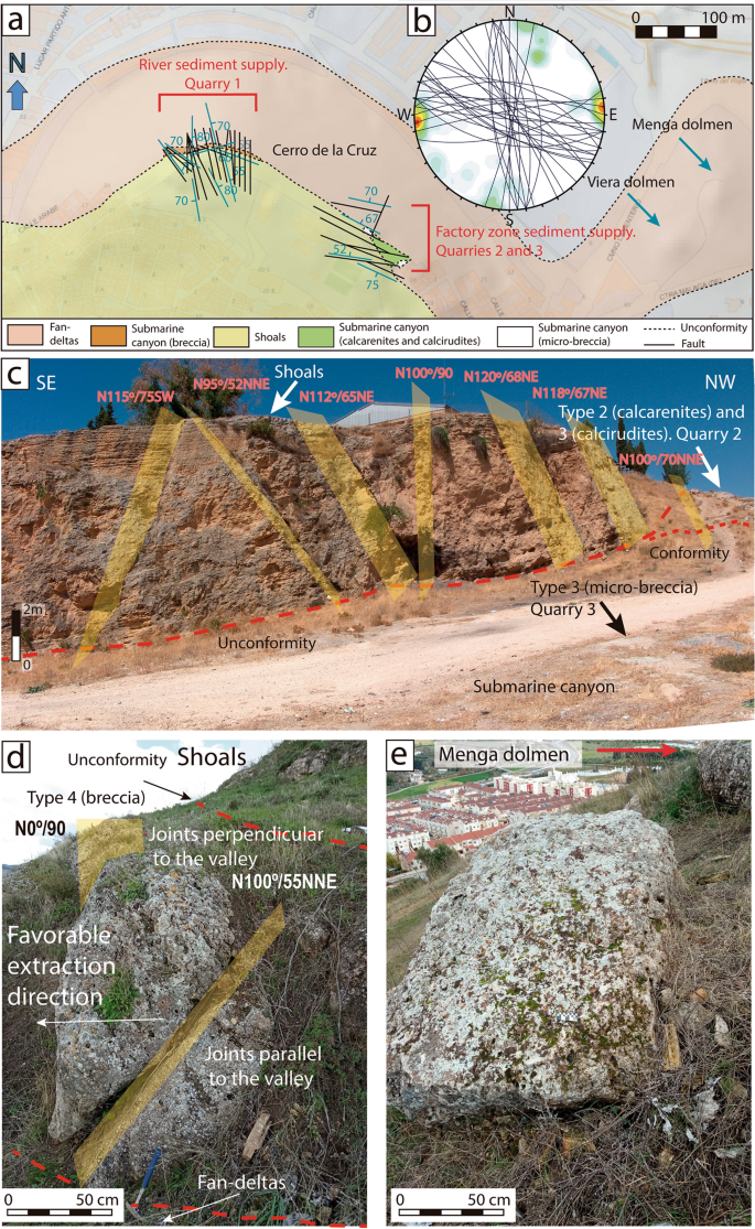
(a) Geological map of tectonic jointing on DTM, showing the location of Menga and Viera and the likely quarrying areas at Cerro de la Cruz. (b) Stereographic representation of the groups of joints. (c) Overview of the tectonic fracturing present in quarry areas #2 and #3. (d) Groups of joints observed in Quarry #1. (e) Example of a possible discarded megalithic stone at Quarry #1. Maps made with Adobe Illustrator based on new field data incorporated to pre-existing geological maps47 DTM data48.
Connecting the dolmen and field lithologies
The rocky outcrop of lithology Type 3 is designated as Quarry #3 (Figs. 2, 3, 5a,c, 6a) corresponding to orthostats O-11, O-15 and capstones C-2 and C-5 (Fig. 2) at the bottom of the submarine canal in which they formed. The stones of this outcrop are identical to those observed in the dolmen (Fig. 6j,k, Tables 1, 2) showing clasts of 0.5–2 cm in size, and small pebbles (1–2 cm), bioclastic, carbonate-matrix and pisoliths. The extensive exploitation of Quarry #3 area in historical periods has prevented us from finding more precise elements of Neolithic quarrying. In this quarry, fractures tend to be arranged verticality, with penetrative spacing of up to 7.5 m (Fig. 5a–c) compatible with the dimensions of capstone C-5 (6.95 × 6 × 1.88 m30).
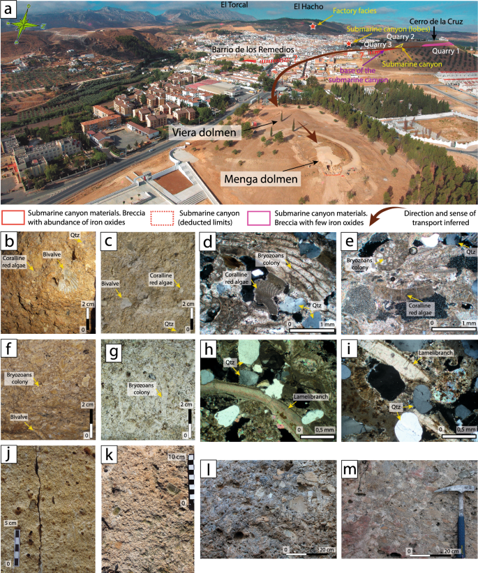
(a) Overview of Menga, Viera, Los Remedios neighbourhood and Cerro de la Cruz from the NE, showing the location of submarine canyons, the factory zone, lobes outcrops (red star) and possible quarrying areas. The direction of stone transportation from the quarries to Menga hill is suggested. (b,c) Detail naked eye of bioclastic calcirudite (lithology Type 1) of in Menga’s orthostat O-10, and quarry #2 respectively. (d,e) Petrographic microphotography of orthostat O-5 (lithology Type 1), and quarry #2 respectively. (f,g) Detail naked eye of bioclastic calcarenite (lithology Type 2) of in Menga’s pillar P-3, and quarry #2 respectively. (h,i) Petrographic microphotography of orthostat O-18 (lithology Type 2), and quarry #2 respectively. (j,k) Detail naked eye of bioclastic micro-breccia (lithology Type 3) of in Menga’s capstone C-2, and quarry #3 respectively. (i,m) Detail naked eye calcareous breccia (lithology Type 4) in Menga’s capstone C-1, and quarry #1 respectively. All photomicrographs are crossed polars light.
In the yard of the La Trinidad Church, located 1.6 km westward of the dolmen, there are outcrops of submarine canyon materials (Fig. S4a–c). However, these are lobe type, and therefore different from those observed in the great dolmen. Also, these rocks show a highly penetrative fracture setting of metric scale, which would render impossible the extraction of large stone blocks. All three candidate quarrying areas stand on soft earthen delta materials, making them ideal quarrying locations.
The outcrop of lithology Type 4 is clearly observable at Cerro de la Cruz, in Quarry #1, ca. 850 m westward of Menga (Figs. 3, 4a,e,f and 6a,m). These materials can also be found at Los Remedios neighbourhood. However, there are clear differences between the two outcrops. Matrix cementation is greater and the amount of pisolith is smaller in Cerro de la Cruz Quarry #1 than in Los Remedios neighbourhood, which is consistent with the lithology of some of the stones in the dolmen (O-22, C-1, C-3 and C-4). Therefore, their origin must be Quarry #1 at Cerro de la Cruz displaying the same type 4 materials (micro-breccia) (Fig. 6a,l,m, Tables 1, 2).
The outcrop of lithology Type 5 presents a very characteristic foreshore materials parallel-laminated formation observed in orthostat O-14. The parallel-laminated formation has caused buckling to orthostat O-14 likely due to the mound and the vertical stress generated by capstone C-5, as these planar discontinuities are unsuitable for this type of monument34 (Fig. S3e). Although this problem has only been noted for this stone, it is, undoubtedly, a design’s flaw of this part of the dolmen. We do not know the origin of this Type 5 lithology, due to the poor conservation conditions of the quarries.
The petrographic study also reveals that the grains of the five lithological types described for Menga are poorly cemented (Figs. 1b1–4,c1–3,d1–2, 6d,h).
This area has been affected by the Alpine tectonic movement, with widespread fracturing, mostly subvertical, which can be seen clearly in the most likely quarrying areas (Figs. 4e, 5a–d). These fractures generated various groups of joints (Fig. 5). In the area designated as Quarry #1, the fracturing presents a prevailing N–S direction, subvertical, or sloping to the E, but others slope to the NNE and, to a lesser degree, to the WSW, and there is even some not-too-vertical ESE fracturing sloping towards the NNE (Fig. 5c). In some cases, these fractures intercept each other. In the areas designated as Quarries #2 and #3, the fracturing is predominantly NE-SW with some NNE, and to a lesser extent SSW, incline (Fig. 5).
The tectonic fracturing present at Cerro de la Cruz is subvertical with barely penetrative spacing at metric scale, thus generating isolated blocks of sizes compatible with those of the orthostats, capstones and pillars of Menga. There is a group of fractures presenting inclination planes of 55° towards the valley and the Menga hill, which was obviously a favourable element for their extraction in Neolithic times (Fig. 5d).
The materials observed at Cerro de la Cruz fully match those identified at Menga. Their topographic position, ca. 100 m above the Menga hill, favoured downhill transportation of the stones. For both reasons, Cerro de la Cruz is the most likely quarrying area for the construction of the dolmen (Fig. 6a). In fact, a non-systematic archaeological survey of this area carried out while analysing the geology led to the recovery of some hand-thrown fragments of pottery compatible with a Neolithic manufacture.